Vecindr logo
Municipality intelligence for Puerto Rico

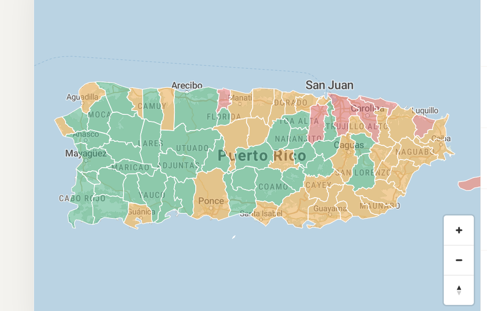
Puerto Rico has78 municipalities.Don't choose one blind.

Search any municipality and see safety, crime, flood risk, power reliability, schools, demographics, economy, and nearby comparisons — before you rent, buy, PCS, or invest.Compare safety, crime, flood risk, power reliability, schools, demographics, and nearby towns before you move.
Full municipality reports are free with an account. PDF downloads from $5.99.Free with account. PDFs from $5.99.
All 78 municipalitiesPRPB · FEMA · Census · BLS · LUMA public dataEnglish & Spanish PDF reports
Sample8-page municipality report · Bayamón, PRBayamón sample report
Includes safety, crime, flood risk, power reliability, schools, demographics, economy, and nearby comparisons.
The deliverable

What's inside every Vecindr report.

Eight pages of verified public-data intelligence on one municipality — safety, crime, flood, power, schools, demographics, economy, nearby comparison, and sources.

Swipe to preview all 8 pages

Page 01
Neighborhood intelligence · PRVCR-72021-BAY
Bayamón
PR · NORTH CENTRAL · 44.0 MI²
F
24.0/100
Safety grade · Composite
PR-wide ranking76 of 78
SafestSafer than 3% of PRAt-risk
Population182,469
Density4,147/mi²
Crimes YTD4,784
Flood zoneAE · High

Safety overview

Grade, score, PR-wide rank, population, crime, and flood snapshot at a glance.

01
Page 02
Section 02VCR-72021-BAY
Executive summary
Overall risk posture
OverallF
CrimeF
FloodF
InfrastructureD
DemographicsB
EconomyC
Ranks 76th of 78 PR municipalities · reported incidents +17.9% YoY.

Executive summary

A plain-English risk posture before you dig into the details.

02
Page 03
Section 03VCR-72021-BAY
PR-wide safety context
Nearby municipalities
BayamónF · 24
Toa AltaA · 85
GuaynaboA · 81
Toa BajaD · 52
NaranjitoA · 85
A.BuenasA · 82
Pueblo41.9
Centro34.1
Sector Norte28.8

Safety intelligence

Puerto Rico-wide context, nearby-town comparison, and local risk patterns.

03
Page 04
Section 04VCR-72021-BAY
04 · Crime category deep dive
Category breakdown
CategoryRate/10kIncidents
Larceny15.98369
Motor veh.3.04362
Agg. assault3.16155
Burglary2.1485
Robbery1.2486
Homicide0.2246
Property 81%
Violent 19%

Crime breakdown

Incident categories, rates, trends, and property vs. violent split.

04
Page 05
Section 05VCR-72021-BAY
05 · Flood, outage & infrastructure
Risk & reliability
FEMA zoneAE · High
GridD
Avg restore14.2h
vs PR median+28%
Flood exposureF
HurricaneD+
Critical facilities in flood zone · 3/24 hospitals · 6/41 schools.

Flood & infrastructure

FEMA flood zone, outage history, grid reliability, and critical facility exposure.

05
Page 06
Section 06VCR-72021-BAY
06 · Demographics & economy
Household profile
Population182,469
Median HH$24,508
Unemployment7.5%
Owner-occ.66.3%
Health & edu23.8k
Retail16.9k
Manufacturing10.7k

Demographics & economy

Population, income, education, employment, and household context.

06
Page 07
Section 07VCR-72021-BAY
07 · Nearby comparison
Crime rate / 10k
MunicipalityRateGrade
Bayamón26.22F
Guaynabo8.16A
Toa Alta6.92A
Toa Baja17.47D
Aguas Buenas7.79A
Naranjito7.10A

Nearby comparison

See how the municipality compares with nearby towns before you commit.

07
Page 08
Section 08VCR-72021-BAY
08 · Methodology & sources
How scores are built
Composite = 0.40 Crime + 0.20 Flood + 0.15 Infra + 0.15 Demo + 0.10 Econ
PRPB NIBRS · Crime incident database
FEMA NFHL · Flood zone mapping
Census ACS 5-Yr · Demographics
BLS LAUS · Labor & unemployment
LUMA Energy · Grid reliability
USGS ANSS · Seismic activity

Methodology & sources

Every figure tied back to named public datasets and update windows.

08
Anywhere you decide

Take the whole report with you.

The same municipality intelligence, condensed into a mobile-friendly summary you can pull up at a showing, on a call, or during a PCS move.

  • See the municipality summary and safety grade in seconds.
  • Check crime, flood, and power risk on mobile.
  • Compare nearby towns before you commit.
  • Download the full PDF in English or Spanish.
  • Use it before renting, buying, PCS, or investing.
Safety grade F24.0 / 100 · rank 76/78
EN & ES PDFready to download
MunicipalityRate / 10kGrade
Bayamón26.22F
Guaynabo8.16A
Toa Alta6.92A
Toa Baja17.47D
9:41
Vecindr
Bayamón
PR · North Central · 44.0 mi²
F
24/100
Ranked 76 of 78
CrimeF
FloodAE · High
PowerD
DemographicsB
Compare
The value

What you're actually paying for.

Not a raw dashboard. Not scattered public records. One clean municipality report that saves you the research and helps you avoid a blind decision.

Every local risk signal in one place

Safety, crime, flood, power, schools, demographics, and economy — organized into one report.

See beyond crime and flood

Power reliability, schools, critical facilities, population, jobs, and local context — the full picture, not two headlines.

Compare before you commit

See how one municipality stacks up against nearby alternatives on safety, crime, flood, density, and infrastructure.

English & Spanish PDFs

Download share-ready reports in both languages for family, partners, agents, or your own records.

Built on verified public data

PRPB, FEMA, Census, BLS, LUMA, and other named public sources behind the report.

Decision-ready, not raw

No agency-hopping. No spreadsheet-wrangling. Just a structured report you can actually use.

Swipe to see what's included →

Doing it yourself
Six agencies, one afternoon gone.
  • PRPB crime portal, FEMA maps, Census tables, BLS data, LUMA outage records — all separate.
  • Raw numbers with no PR-wide benchmark.
  • No easy way to compare one town to its neighbors.
  • No clean English / Spanish PDF to save or share.

Result · scattered tabs and a guess.
With Vecindr
One report. Eight pages. Minutes.
  • Key risk signals compiled into one report.
  • Benchmarked against all 78 Puerto Rico municipalities.
  • Nearby comparison included.
  • English and Spanish PDF.
  • Sources cited throughout.
Result · a decision-ready municipality view.
Questions

Before you buy.

What can I see for free?
Create a free account and see the complete municipality report — safety scores, crime breakdown, flood zones, schools, outage history, and demographics. Anonymous visitors see the safety grade and score only.
What's in the full report?
Eight pages: cover snapshot, executive summary, safety intelligence, crime deep dive (by category), flood & infrastructure, demographics & economy, nearby comparison, and methodology & sources.
How current is the data?
Crime data from PRPB NIBRS is updated annually. Flood zones from FEMA NFHL, demographic and economic data from Census ACS 5-year estimates, and grid data from LUMA are refreshed on their respective public-release schedules.
Can I get the report in Spanish?
Yes. Every paid PDF download includes both English and Spanish versions — same data, both languages, ready to download and share.
What does the safety score measure?
The composite score weights crime (40%), flood risk (20%), infrastructure (15%), demographics (15%), and economy (10%). The final letter grade maps to the same 0–100 scale Puerto Rico uses for school performance.
Who is Vecindr for?
Anyone making a location decision in Puerto Rico — families relocating, service members on PCS orders, remote workers, investors, landlords, and real estate agents who want to give clients a cleaner picture.
Is this legal advice or an official government source?
No. Vecindr aggregates and presents verified public data for informational purposes only. It is not legal, real estate, or investment advice. All source data is attributed and publicly available.
Can I share the report with my family or agent?
Yes. Download the PDF and share it however you'd like — email, WhatsApp, print. The report is yours once you purchase it.

Know the municipality
before you move.

Search any of Puerto Rico's 78 municipalities. Create a free account to see the full report.

Full reports free with account · PDF downloads from $5.99 · See pricing →